Works – the so-called “FourTracking“ – have been underway for some time on the railway line through east Bristol up Filton Bank between Bristol Temple Meads and Filton Abbey Wood stations.
The “FourTracking” entails increasing the capacity up Filton Bank by replacing the two sets of tracks that were removed between some 35 and 40 years ago. The route up Filton Bank is used by mainline services to both South Wales and the Midlands, as well as by local rail services.
On the section of Filton Bank between Dr Day’s Junction and Stapleton Road station, the majority of the current work entails clearing away 3 decades of detritus and refurbishing the infrastructure, including the original drains in the cutting. At Lawrence Hill station, this has included refurbishing a culvert, as I found out looking over the railway bridge the other day.
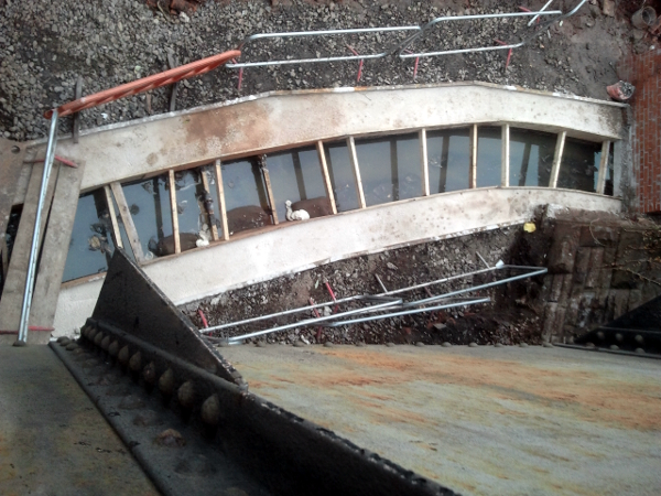
I was intrigued by the slight curvature of the culvert as drains are normally straight. What could this be?
To find the answer your ‘umble scribe had to search maps dating back to the late 19th century. These are available through Bristol City Council’s Know Your Place website.
No clues were forthcoming from the 20th century maps and other resources available. However, the 1880 Ordnance Survey mapping for Lawrence Hill revealed what the culvert actually was. It carries the Wain Brook – one of Bristol’s hidden watercourses – under the railway.
If you examine the image below, it will be noted that Lawrence Hill railway bridge lies between the two sections of the Wain Brook then running above ground – one to the right of the bridge past the “Wainbrook Works” and the other section to the left past open ground (now a park).
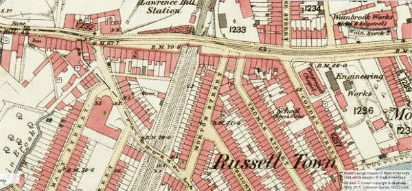
Very little information is available online about the Wain Brook itself. Judging from the map evidence its source seems to be in the region of Plummers Hill in St George and in times gone by it flowed across the fields that were to become St George Park. After the park’s creation, the Wain Brook was used to feed its ornamental lake.
From can be surmised from the sparse clues available, from Lawrence Hill the Wain Brook – still in culvert – flows down Lincoln Street (site of the Wain Brook Elderly Persons Home. Ed.), past Gaunt’s Ham Park and through St Philips and the Dings (where some 200 years ago it flowed through withy beds) to empty into the River Avon at a point near Bristol Temple Meads station.
The Church Crawler web page for St Luke’s Church in Barton Hill contains the following reference to the Wain Brook.
In the early 1800s Barton Hill was described as a small rural hamlet comprising mainly of wheat fields and orchards with a stream, The Wain Brook, running through and dominated by two large houses namely, Tilley’s Court and Royal Table House.
The earliest historical reference to the Wain Brook that my research has turned up dates back to the 13th century, when in the manor of Barton Regis (present-day Barton Hill) there was a meadow belonging to St Mark’s Hospital called ‘Wainbroke’ (after the Wain Brook) that extended between the ‘meadow of the hospital of St Lawrence of Bristol and the meadow formerly of Richard de Pisa’.
The hospital of St Lawrence of Bristol was Bristol’s medieval leper colony (St Lawrence was the patron saint of lepers and leper colonies were always established beyond the built-up areas of medieval towns and cities. Ed.), which was founded by King John in 1208 when he was Earl of Mortain. The hospital’s establishment gave its name to the whole area. Lawrence Hill roundabout now occupies the vicinity of the site where the hospital is thought to have stood.
If readers have further information to add about the Wain Brook, please feel free to comment below.